Multiple glaciations have shaped the Prairies Ecozone. Continental glaciation flattened the landscape and left behind a variety of glacial deposits. For example, the flat fertile plain that dominates southern Manitoba resulted from the heavy clay soils that lay beneath the former glacial Lake Agassiz. Cedar Lake and lakes Manitoba, Winnipeg, and Winnipegosis are remnants of this bygone inland sea. Ponds and small lakes occupy many of the depressions in moraines. Following the glacial retreat 8 000 to 11 000 years ago, the ecozone evolved into treeless grasslands covering the southern third of what is now Alberta, Saskatchewan, and Manitoba.
Underlying these surface landforms are horizontal layers of sedimentary bedrock consisting of various Cretaceous and Tertiary sediments. Trapped in isolated pockets and cracks are rich reservoirs of oil and gas.
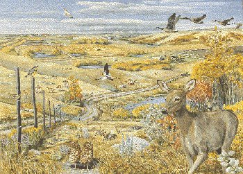
The Prairies Ecozone is now typified by large tracts of flat to rolling plains. A great variety of surface landforms, from hummocky lands to deeply entrenched river valleys, also exist.
Most of the major rivers have their origin in the Rockies. These rivers flow east across the ecozone and are fed by rainfall, snowmelt, and glacial runoff at their headwaters. Many smaller rivers and streams of the Prairies Ecozone have highly variable flows and are often dry for long periods.
The ecozone’s climate is determined by its location in the heart of North America and by the neighbouring Rocky Mountains, which block moisture-bearing winds from the Pacific. The result is a pronounced, subhumid to semi-arid climate. Winters are very cold. The mean temperature in the coldest month is -9.4oC at Lethbridge and -18.3oC at Winnipeg. Summers are short and warm. Mean temperatures for the warmest month are 16.1oC at Edmonton and 19.7oC at Winnipeg. Although dry, arctic air predominates in winter, periodic chinooks (strong, warm and dry westerlies that blow in from the Rockies) bring spring-like conditions to southern Alberta and, to a lesser extent, southern Saskatchewan, reducing snow cover and removing moisture from an already dry region.
A water deficit is typical as the ecozone receives considerably less precipitation than other parts of Canada and the world. Annual precipitation is extremely variable, ranging from 250 mm in the arid grassland regions of southwest Saskatchewan and southeast Alberta to slightly less than 700 mm in the Lake Manitoba plain, the warmest and most humid region in the Prairies Ecozone. About a quarter of the precipitation falls as snow. Summer thunderstorms are often severe, and south-central Alberta is reputed to be one of the worst hailstorm belts in North America. In summer, warm, moist air masses from the southern United States invade southern Manitoba, causing numerous thunderstorms and occasional tornadoes.
High winds predominate in the ecozone. Mean annual wind speed in many places is 18 to 21 km/h. In contrast, Vancouver's mean annual wind speed is 12 km/h while Toronto's is about 16 km/h. Wind accelerates evaporation, causing much of the dryness. In combination with precipitation and evaporation patterns, wind determines the amount of soil erosion and the resulting land degradation.