The Prairies Ecozone is often characterized as flat, rural, wheat- and oil-producing, or cold. The terms describe significant aspects of the environment and the economy but understate its diversity and recent evolution.
This ecozone is part of the Interior Plains of Canada, which are a northern extension of the Great Plains of North America. The relief is typically subdued, consisting of low-lying valleys and plains sloping eastward. With its base along the Canada-United States border, the ecozone stretches from the Rocky Mountains in Alberta to the Red River valley in Manitoba, reaching across the southern third of the Prairie provinces.
The Prairies Ecozone, spanning an area of 520 000 square kilometres, is larger than the Yukon Territory and is one of the Canadian regions most altered by human activity. Farmland dominates the ecozone, covering nearly 94% of the land base.
Termed the Breadbasket of Canada, the Prairies Ecozone contains the majority of the country's productive agricultural cropland, rangeland, and pasture. The area is the source of much of our food and, as a result of the export of grains, oilseeds, and animal products, is an important source of foreign exchange.
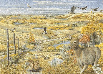
Agriculture is the major agent of change in this ecozone, influencing most native communities of plants and animals. Loss of habitat is the most critical threat to the flora and fauna. Little of the natural vegetation is left, a situation that made life difficult for some animals unique to the grasslands. Wetlands, which provide critical habitat for 50% of North America's waterfowl, have been altered by agricultural practices and only half the presettlement wetland area remains. Today, the Prairies Ecozone is home to high numbers of threatened and endangered wildlife species and its native ecosystems are among the most endangered natural habitats in Canada.