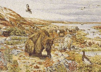
The last glaciers finally retreated from this area about 8 500 years ago. As the 3-km thick ice sheet melted, it released a huge volume of soil and rock debris, which is now strung across the landscape in the form of corrugated piles of bouldery moraine, and etched by long eskers extending up to 100 km. Occurring less frequently are outwash aprons of crudely sorted sand and gravel, and raised beach ridges along the shores of phantom preglacial lakes. The resulting undulating terrain is studded with innumerable lakes and ponds. Some of these water bodies formed in "kettle" depressions created when ice blocks, abandoned by the main ice sheet, became engulfed by glacial drift and then melted away.
Occasionally emerging through this thick mantle of glacial deposits is the Canadian Shield, which consists mostly of granite bedrock. The most recent passage of the glaciers can still be read in these rocks, which often show fine lines in the bedrock carved by rock fragments embedded in the bottom of the advancing ice sheet.
On its journey south, the glacier plucked large chunks of rock from weak spots in the Canadian Shield. These rocks, some the size of houses, may have rafted along on top of the glacier, been bulldozed forward by its nose, or carried below. Dropped a few metres or a few thousand kilometres from their source, these rocks sometimes have little in common with the surrounding bedrock, hence the name "glacial erratic."
Permafrost occurs continuously throughout the Southern Arctic Ecozone. Lying sometimes just a few centimetres below the surface, it acts as a dam that stops the downward flow of water. Consequently, even though there is little precipitation here, the soils are often waterlogged or frozen. Repeated freezing and thawing of these soils creates interesting features on the surface, including cell-like polygons, bulging hummocks, and bare mud boils where the soil is so active that no plants can take root. Intense frost heaving often splits apart the underlying bedrock and forces large angular "boulders" to the surface.
Summers are short (about four months), cool, and moist, whereas winters are long and extremely cold. Total annual precipitation is usually less than 250 mm in the west and rarely more than 500 mm in the east.
