Most Canadians -- about 77% -- live in cities. Buildings, roads, utility lines, vehicles, and other people surround us. Apart from some parks and other urban green spaces, the "environment" is something that for the most part exists elsewhere, at some distance from the urban core.
Seen from space, however, Canada shows no roads, no political boundaries, no languages, no politics, and no people. The country's appearance is strikingly different from this distant perspective. It is surrounded by three massive oceans, contains a large share of the world's fresh water, and has 25% of the world's major wetlands. Vast stretches of land are occupied by the arctic barrens, the great plains, the forests, and the western mountains. Ocean currents swirl around the margins of the continent and weather patterns move over the land and ocean masses. Virtually hidden from this distant view are tens of thousands of species of plants and animals as well as more than 30 million human beings.
This faraway view of the nation is compelling because it forces us to think of ourselves as an integral part of the Earth's ecosystems, not separate from them. Just as images taken from space are relatively new, so too is the broad realization of the human partnership with the environment. Although some people have long recognized the need for an integrated or holistic understanding of ecosystems, most have only recently come to understand the urgency for such an approach.
From bits and pieces
Glimpses from satellites and space shuttles remind us of the big picture: that we live within broad ecological zones on the Earth's surface. Ironically, our knowledge about those ecosystems has grown through a process that emphasized studying the bits and pieces and disregarding the whole. The human activities associated with these ecosystems have therefore reflected a similar preoccupation with the parts rather than the whole.
As one of the largest nations on the globe, Canada has a diversity of landscapes and seascapes that is seemingly endless -- temperate forests and arctic barrens, extensive river systems and coastlines, vast plains and imposing mountain ranges, farmscapes and wilderness, wetlands and deserts, Great Lakes and prairie potholes, ranging from relatively untouched to highly stressed systems. The variety can be overwhelming. Naturalists, scientists, and many others have contributed to describing these natural zones. A wealth of maps and reports emerged. Some described biological features such as general vegetation, forests, wildlife, habitat, and peatlands. Physical descriptions focused on climate zones, bedrock types, marine areas, permafrost patterns, landforms, and soils. Other classifications specifically addressed types of human activity (e.g., rural land uses or urban settlements) or cultural groupings (e.g., Inuit region). These thematic or single-purpose studies are quite reliable tools for studying component parts of ecosystems. But in cases where it is important to understand the relationships between people and the environment, between wildlife and wildlife habitat, and between carrying capacity and resource use, the existing information tends to be rather piecemeal.
Problems with an incomplete view
Studying the component features of ecosystems has contributed to our understanding of Canada's biological and physical diversity. For the purposes of environmental management and sustainable resource use, however, this piece-by-piece approach has led to an incomplete and often misleading view.
There are those who are involved in planning and management of ecosystems and others who look at ecosystems from the standpoint of impact assessments, sustainability strategies, environmental indicators, economic factors, monitoring systems, or public reviews. There is so much work to be done in all these separate areas that we have been slow to develop an integrated and holistic approach. Yet without a broad ecosystem perspective, it is becoming increasingly difficult to address environmental goals. Many interests are at stake, and there are short-term and long-term considerations. There are questions about the balances of land and water use to be answered; conservation and exploitation perspectives to be weighed; local and distant benefits and costs to be assessed; cumulative effects to be measured; and political, social, environmental, and economic values to be evaluated. Understanding the wide ecosystem context is vital today.
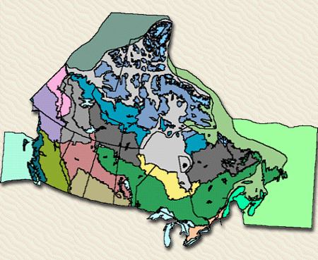
Canada has a mosaic of distinctive ecosystems, many of which are unique in the world. There are 20 major ecosystems -- ecozones -- in Canada: 15 terrestrial ecozones and 5 marine ecozones. The marine ecosystems cover parts of three major oceans settings---the Pacific, Atlantic and Arctic. The terrestrial ecozones largely cover a broad range of forested, taiga and arctic ecosystem types. Canada also has significant representation of ecosystems which were formerly native grassland areas.
AN ECOZONE PERSPECTIVE
Many tools are used to convey the notion of ecosystems and their all-encompassing nature. Because people are accustomed to thinking in terms of defined spaces, of seeing their lot, municipality, or country represented on a map, depicting ecozones on a map is a fundamental starting point. Political maps show legally delineated spaces, such as city or provincial boundaries, but this type of mapped information is not of primary importance in the early stages of applying an ecosystem approach. In contrast, ecozone maps define spaces in an ecologically meaningful way. Expressing ecosystems as units on a map provides a basis for understanding their structure and composition.
The ecosystem units are used like a comprehensive set of information folders. The folders allow different agencies and jurisdictions across Canada to contribute their expertise and information on particular elements of ecosystems. They also allow people to draw from the expertise of others. The ecosystem units have become a common protocol to build a profile and understanding of Canada's ecosystems. Common sense and ecosystem concepts What is meant by an ecozone? People intuitively capture the meaning by the simple phrases they use to describe the large ecological areas of which they are a part. For example, consider all the attributes and relationships that are implied by phrases such as the prairie grasslands, the plains Indians, the great central plains, Canada's breadbasket, the ranching heartland, the home of the buffalo, the nation's largest farmscape, the prairie climate, the grassland soils, big sky country, and the prairie wetlands and potholes.
Beyond expressing something about the obvious characteristics of the area, these phrases fashion a broader impression of a specific geographical location and of a vast open space. The mere word "prairies" evokes an image of large expanses of grain or rangelands that cover the southern parts of Alberta, Saskatchewan, and Manitoba. The phrases equally start to describe particular biophysical features and underlying relationships. The prairies have been a valued cereal grain production area for many decades. What interactions among environmental, economic, and cultural elements have caused this to be so? Many factors are connected to why the region is so productive for agriculture -- the deep and nutrient-rich soils, the extensive tracts of flat or gently rolling land, the inherent adaptability of grassland species, the ease of cultivation, the warm, dry climate, and so on. Common sense tells us about the uniqueness of an area like the prairies, the mosaic of particular characteristics and the inherent relationships that exist in that zone.
An ecozone, then -- like any ecosystem -- is an area where organisms and their physical environment endure as a system (Wiken, 1986). Because of the large size of ecozones, the types of criteria that are used to define them are geared to broad, common characteristics. For instance, plants would be defined by major plant formations (e.g., boreal spruce) rather than by more detailed classifications such as plant communities (e.g., Black Spruce-Feather Moss community). Landforms and soils would be defined in a similar way, by large physiographic divisions (e.g., mountain ranges) and soil orders rather than by local landforms (e.g., a specific hill) or soil series.
Ecosystems can be of any size. They are not equal in kind or in the variety of their characteristics. They may refer to local wetlands, the Gulf of St. Lawrence, the circumpolar arctic area, or the entire Ecosphere. Big or small, they are part of a continuum -- like a family, a community, or a nation -- the components of which interact with and affect one another. The trends and conditions that are associated with the bigger ecozone units must be put in the context of what happens locally, in ecodistricts, as well as in ecosystems of global scale. If the reproduction of eastern migratory birds is weakened, for instance, the effects of the population declines reverberate throughout North America. Local and global events and conditions are linked by the age-old processes of nature as well as by human activities. The arctic ecozones are affected by ocean ecosystems that originate from as far away as the equator, by migratory birds that winter in Mexico, and by pollution that emanates from Russia's industrial heartland. On the west coast, forestry operations can cause soil erosion that impairs salmon breeding grounds; if the salmon population is not renewed the decline in numbers will adversely affect the coastal fishery in three to five years. Defining ecozones How is an ecozone determined? What were the key diagnostic characteristics for each Canadian ecozone? Were the same characteristics used for each? Which characteristics are essential and which are incidental?
In part, the answer to these questions is based on what common sense would suggest. In any large ecosystem -- the forested mountains of the west coast, the arctic lowlands of the Northwest Territories, the great plains of the prairie provinces -- the particular combinations of characteristics like climate, landforms, soils, plants, animals, and human activities are distinctive. These combinations remain relatively constant for each ecosystem.
Standards and guidelines exist for describing ecosystems (Wiken 1986; ESSG,1996). Ecozones still have to be judged on a case-by-case basis. Characteristically, they are large units (i.e., greater than 200 000 km2). Most of the diagnostic features are factors normally thought of as natural -- landforms, soils, water features, vegetation, climate. However, where human activities are extensive and are key to sustaining the character of the area, they are also diagnostic. Agricultural activity is a fairly diagnostic feature of the Prairies Ecozone; the occurrence of certain types of soils, the plains physiography, the former extent of native grasslands, and other features would also be considered in determining the boundary and traits of this particular zone.
DIVERSITY OF CANADIAN ECOZONES
Canada has a mosaic of distinctive ecosystems, many of which are unique in the world. There are 20 major ecosystems -- ecozones -- in Canada: 15 terrestrial ecozones and 5 marine ecozones. The legend on the map arranges the ecozones according to general shared properties. For instance, all of the marine units are grouped, as are the boreal and arctic units.
Ecozones vary in shape and size. The largest in Canada -- the Boreal Shield Ecozone -- is an irregularly shaped area stretching across parts of six provinces. It is bigger than the state of Alaska, the country of Mongolia, and the province of Quebec. It takes less time to fly from New York to London, England, than it would to fly the length of the Boreal Shield. Canada's three arctic ecozones, which occupy diagonal bands across the North, collectively cover an area more than four times the size of France. The main wetland-dominated ecozone -- the Hudson Plains -- is larger than Italy and is the world's largest wetland area.
Ecozones vary in diversity as well. For instance, the Prairies Ecozone is less diverse than the Pacific Maritime Ecozone. The Pacific Maritime unit is a lot like a layer cake. Temperate rain forest dominates much of the lower and mid elevations, but the base includes areas such as semi-Mediterranean arbutus and Garry Oak woodlands while, several layers higher up, alpine meadows and snow packs dominate.
Ecozones also differ with respect to their opportunities and constraints for particular activities and uses, such as agriculture, forestry, fishing, and recreation . For instance, although agriculture is successful in many areas across the country, it is predominantly associated with the Prairies and Mixedwoods Plains ecozones.
Some of Canada's ecozones are shared with other countries. For example, the seemingly small Prairies Ecozone (450 000 km˛) is, in fact, only the northern tip of a unit that reaches well into the heartland of the United States. This ecozone also forms part of the world's set of temperate grasslands. Similarly, Canada's arctic ecozones form a vital segment -- about 20% -- of the world's total arctic ecosystems.
Further Reading
Environment Canada. 1996. The state of Canada's environment 1996. State of the Environment Directorate, Environment Canada, Ottawa K1A OH3.
Ecological Stratification Working Group. 1996. A national ecological framework for Canada. Ottawa: Agriculture and Agri-Food Canada, Research Branch, Centre for Land and Biological Resources Research; and Ottawa: Environment Canada, State of the Environment Directorate, Ecozone Analysis Branch.
Wiken, E.B. 1986. Terrestrial Ecozones of Canada. Ecological Land Classification, Series No. 19. Environment Canada. Hull, Quebec. 26pp. + map.
Wiken, E. B. 1996. Ecosystems: frameworks for thought. in World Conservation. Volume 27, Number 1. IUCN, Gland, Switzerland.